Mormon trail folded map
Side One (left) and Side Two (right) - For larger images, scroll down further below.

|

|
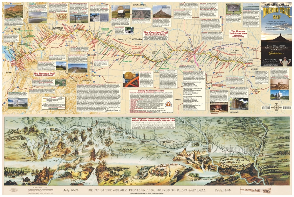
Side One shows the historic artwork titled Route of the Mormon Pioneers from Nauvoo to Great Salt Lake, a map produced in 1899, with a parallel modern map that follows the Mormon Trail from Nauvoo, Illinois to Salt Lake City, Utah. Both sides of the map are full of photos, captions, and historical notes, making this basically a guide book in map form.
Side Two, the reverse side of the map, details the major stops along the Mormon Trail. This includes Nauvoo, Salt Lake City, Temple Square, Echo Canyon, Emigration Canyon, Martin’s Cove, Independence Rock, Mount Pisgah, Winter Quarters, Guernsey Ruts, South Pass, and more.
Side Two, the reverse side of the map, details the major stops along the Mormon Trail. This includes Nauvoo, Salt Lake City, Temple Square, Echo Canyon, Emigration Canyon, Martin’s Cove, Independence Rock, Mount Pisgah, Winter Quarters, Guernsey Ruts, South Pass, and more.
More about this map:
On Christmas Day 2013 I at last began in earnest to create the Mormon Trail map, detailing the Mormon Trail from Nauvoo, Illinois to Salt Lake city, Utah, including pioneer history as well as places that can be visited today. I’d been thinking about and preparing to make this map since I first had the idea in 1978.
The map is a tribute to tens of thousands Latter-day Saints who crossed the plains to Utah from 1846 until 1869. This includes some of my own ancestors: Great-Great Grandfather Peder Nielsen and family, Great-Great Grandfather Samuel Gadd, who died on the plains of Nebraska with the ill-fated Willie Handcart Company, and Great-Grandfather George Josiah Marsh.
I had this map in my head for all these years and always knew that one day I just had to make it, yet until 2014 I was “genealogy-challenged” and knew nothing of my own pioneer heritage!
The work to create this map included firsthand experience on the trail and much inspiration from learning about my ancestors.
The Mormon Trail map is 37.5” x 25” and folds down to 4” x 8.5”. It is printed on waterproof, extremely durable synthetic paper.
After 36 years in the making, my Mormon Trail map has at last been completed, and it will guide you and tell you the amazing story of the Mormon Exodus, which is one of the great chapters in American history.
Whether or not you desire to trace the Mormon Trail yourself by car, or by bike, or even if you want to pull a handcart across a piece of Nebraska, Wyoming, or Utah, this map will guide and inspire you, and help you to understand how amazing the Mormon pioneers truly were.
Any retailers who are interested in selling this map in their stores, please e-mail me at:
[email protected]
I am Frank Nielsen, great-great grandson of Mormon pioneers, and professional map man at your service.
For the full story of how my Mormon Trail maps were created, see the "About" section of this website.
Larger images of Side One (top) and Side Two (bottom) of the Mormon Trail folded map: